Historic and Heritage Landscape Mapping: Hong Kong Practices and Methodologies
Event Date:
25/03/2026
Event Time:
6:00 pm
Event Location:
Online
Event Details 活動詳情:
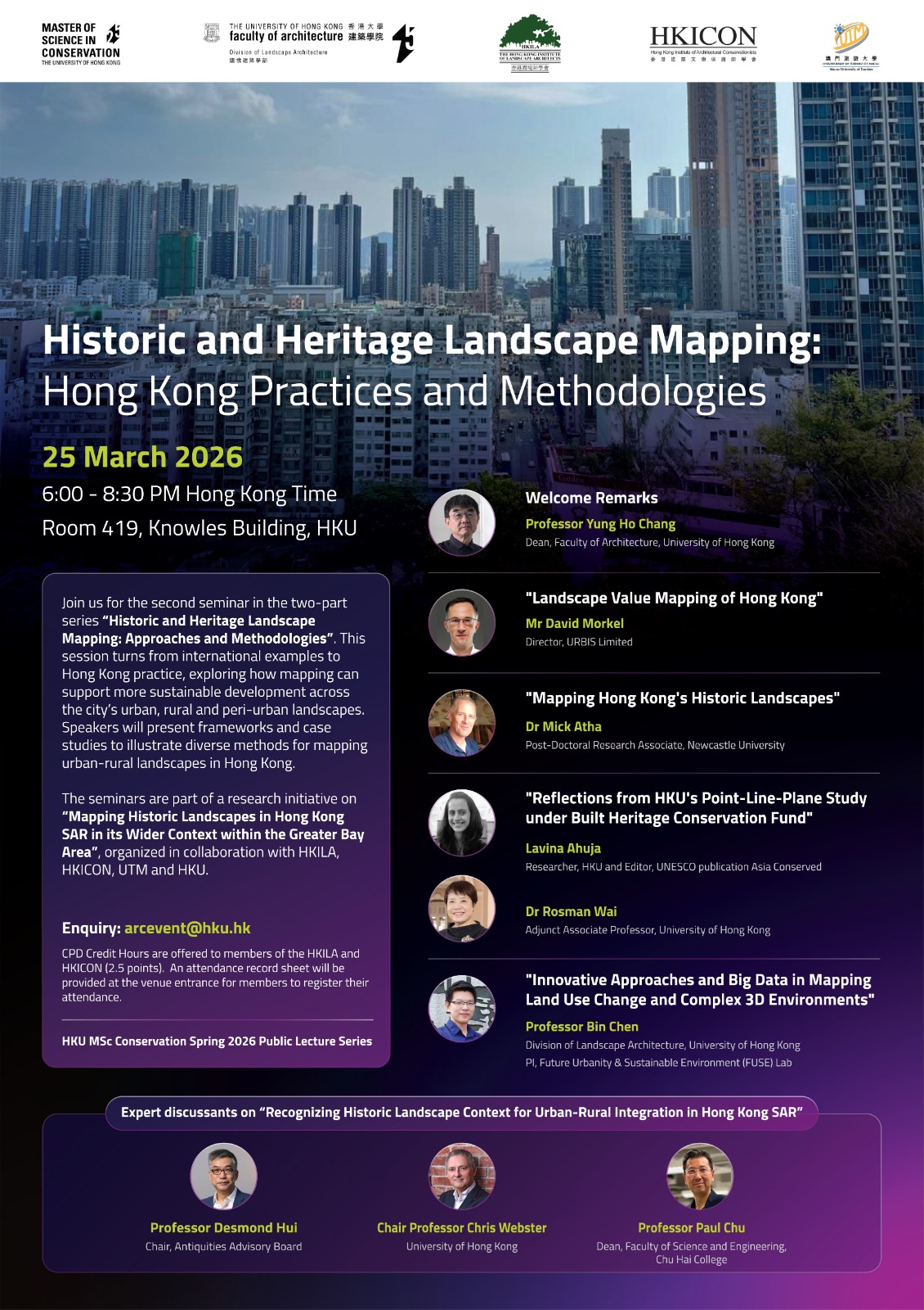
| Event: | HISTORIC AND HERITAGE LANDSCAPE MAPPING: HONG KONG PRACTICES AND METHODOLOGIES |
| Date: | 25 March 2026 (Wednesday) |
| Time: | 6:00pm – 8:30pm Hong Kong Time |
| Registration: | Pre-registration is not required. (The lecture is open to the general public) |
| Speaker: | “Landscape Value Mapping of Hong Kong”
Mr David Morkel, Director, URBIS Limited
“Mapping Hong Kong’s Historic Landscapes” Dr Mick Atha, Post-Doctoral Research Associate, Newcastle University
“Reflections from HKU’s Point-Line-Plane study under BHCF” Lavina Ahuja, Researcher, HKU and Editor, UNESCO publication Asia Conserved & Dr Rosman Wai, Adjunct Associate Professor, Faculty of Architecture, University of Hong Kong
“Innovative Approaches and Big Data in Mapping Land Use Change and Complex 3D Environments” Professor Bin Chen, Division of Landscape Architecture, Faculty of Architecture PI, Future Urbanity & Sustainable Environment (FUSE) Lab
Expert discussants on “Recognizing Historic Landscape Context for Urban-Rural Integration in Hong Kong SAR” • Professor Desmond Hui, Chair, Antiquities Advisory Board
|
| CPD Points: | 2.5 CPD credit hours |
| Language: | English |
| Fee: | Free of charge for HKICON Members, HKICON Friends, HKICON Student Members, and non-HKICON Members. |
| *During the seminar, an attendance record sheet will be provided at the venue for members to register their attendance.. | |
| Remarks: | Members can apply for CPD points (equivalent to the hours attended) via the self-claimed CPD platform, providing an attendance certificate of the event. |
About the CPD 活動簡述:
Join us for the second seminar in the two-part series “Historic and Heritage Landscape Mapping: Approaches and Methodologies”. This session turns from international examples to Hong Kong practice, exploring how mapping can support more sustainable development across the city’s urban, rural and peri-urban landscapes. Speakers will present frameworks and case studies to illustrate diverse methods for mapping urban-rural landscapes in Hong Kong.
The seminars are part of a research initiative on “Mapping Historic Landscapes in Hong Kong SAR in its Wider Context within the Greater Bay Area”, organized in collaboration with HKILA, HKICON, UTM and HKU.
(Image courtesy of Master of Science in Conservation and Division of Landscape Architecture)
Remarks 備註:
- Video recording / Photographing of the event will be conducted for promotional and archival purposes. If participants prefer not to be included in the video/photo, please let us know on the date before the event starts.
- For enquiries, please contact arcevent@hku.hk